

LCB Research: Sky Islands Landscapes, 2013-2016
This project was all about the thesis project of M.S. student, Nicole Shaw, who was co-advised by Dr. Brett Dickson of Northern Arizona University and funded by Conservation Science Partners. The following description is slightly modified from her thesis abstract.
The Sky Island region of the southwestern United States hosts some of the richest biodiversity anywhere in the world. In the mountain ranges of the Sky Islands, most vertebrate biodiversity is dependent on riparian areas for all or some of their life cycles. Riparian vegetation is threatened by human impacts and climate change. Though riparian vegetation along rivers and major perennial streams is already mapped in this region, vegetation in ephemeral and intermittent riparian areas, arguably equally important for biodiversity in the mountain ranges, has not been quantified. I developed a Random Forest classification model of riparian vegetation for all three types of riparian areas, mapped this vegetation for each of the 25 mountain ranges, described the spatial distribution and connectivity of the vegetation among and between mountain ranges, and demonstrated enhancement of regional riparian land cover classes with the new model of riparian zone vegetation. The resulting map indicates a much broader distribution of riparian zone vegetation than previous land cover mapping efforts indicate, likely due to inclusion of ephemeral and intermittent riparian types. The spatial distribution and connectivity of riparian zone vegetation varied widely within and between mountain ranges, possibly as a result of variability in environmental factors affecting aridity, temperature, water availability, landscape position, and disturbances. The model can be used with other information to augment understanding of the integrity, connectivity, and vulnerability of riparian zone vegetation in this unique and important region. To analyze the conservation status of riparian zone vegetation, I quantified its representation in protected areas. I then compared the representation relative to the overall amount of riparian zone vegetation in each mountain range. The relationships between representation of riparian zone vegetation in protected areas, degree of mountain range protection, and amount of riparian zone vegetation are complex and variable among mountain ranges. I used patterns of representation to place protected status of riparian zone vegetation in a regional context, highlighting mountain ranges where riparian zone vegetation is well-represented in protected areas as well as locations where further investigation may be warranted to understand conservation status and potentially vulnerable riparian areas. These outcomes benefit agencies and organizations that require spatially-explicit information about the amount, connectivity, and distribution of riparian zone vegetation and its representation in protected areas across the region for conservation, management, and planning.
People: Shaw, Albright
Key collaborators: Dr. Brett Dickson (Northern Arizona University, Conservation Science Partners)
Funding: Conservation Science Partners
Relevant Publications: pending
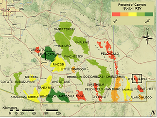
The percent of canyon bottoms that is riparian zone vegetation (RZV) summarized for each mountain range of the study area (from Shaw et al. in prep).
The percent of canyon bottoms that is riparian zone vegetation (RZV) summarized for each mountain range of the study area (from Shaw et al. in prep).

Representation of RZV in protected areas by percent RZV in GAP status 1 and 2 lands for each mountain range. Red indicates zero protection, dark green the most protection, and yellow the median level of protection (17%; from Shaw et al. in prep).